There’s only so much you can say about the destruction that occurred over the border in Massachusetts. A tornadic supercell seems to have produced a tornado over an exceptionally long swath from Westfield to Southbridge, Massachusetts. A path that long is something unusual for Oklahoma and is exceptionally rare in New England.
Yesterday I drove to Monson, MA one of the towns hardest hit, to report for our 11 p.m. newscast. I arrived around 7:15 p.m. and walked from the barricade on Rt. 32 south of downtown to the hardest hit area. A 1/4 to 1/2 mile swath on Main Street suffered extremely severe damage with some locations likely experiencing EF-3 damage. On Washington Street one house was completely flattened and unrecognizable with a neighboring garage swept off its foundation and blown 50 feet.
Further east, on Bethany Rd., damage to houses was apparently worse and more severe but it was impossible to get there with the huge piles of debris filled with nails, utility lines, and scraps of metal. One house on Washington Road was flattened like a pancake and all sorts of things from the house were littered across the street. A cordless phone, a picture frame, a fax machine, and a coat rack. Inside the debris a frightened cat was hiding under a pile of 2 by 4s unsure where to go. I was able to coax the cat out but he ran down the street before I was able to get him.
The meteorology for this event was just surreal. It became very apparent to me about 24 hours before that this had the potential to be big. The elevated mixed layer and signs of strong low level wind shear and an upper level disturbance approaching during peak heating of the day were glaring signals. Once the supercells formed they quickly turned tornadic. This is the first sign of the tornado on Doppler Radar over Westfield.

KBOX Radar Storm Relative Velocity
Incredibly, even with a reported funnel cloud at Barnes Airport, there was no tornado warning on this storm until about 10 minutes after the storm struck Westfield. Radar showed strong rotation over Westfield about 15 minutes before the tornado warning was issued. The funnel was observed by the airport at 4:23 p.m. and it took until 4:30 p.m. for the warning to go out. By the time the storm got to Springfield the warning was posted and WWLP-TV showed live video of the storm leaving West Springfield and crossing the Connecticut River.

Picture from WWLP-TV
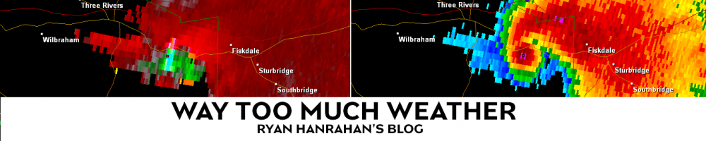
From the pictures and video I’ve seen from Westfield, West Springfield, and Springfield it appears the tornado did EF-2 damage. Unfortunately the tornado only strengthened as it moved east. Here is the storm on radar shortly after passing Monson.

Taunton Storm Relative Velocity and 0.5 deg. Base Reflectivity
This is about the most frightening radar image you can see. Besides >100 knots of gate-to-gate shear (which shows strong rotation) there is a classic debris ball being picked up on the radar at at elevation of about 6,500 feet. What this shows is pieces of debris picked up by the tornado and showing up as high reflectivity on the radar. Debris balls are an indication of a substantial tornado on the ground and doing significant damage to structures and trees.
The National Weather Service will be conducting damage surveys today to see how wide, long, and strong the tornado was. My estimation was high end EF-2 damage and low end EF-3 damage on Monson. I know there were some pockets of worse damage in parts of Monson, Brimfield, and Southbridge that could have been high end EF-3 or higher but I was unable to view these areas personally for safety reasons after dark and time constraints.
Will try to post some of the video we shot last night in Monson when I can. My thoughts are with the people of Massachusetts who have a long and emotional clean up ahead of them.

Ryan, a great recap of an incredible weather day. One question why didn’t NWS get a warning out when they sighted a funnel at the Westfield Airport, would had given Springfield a bit more time to prepare, wouldn’t it?
Ryan,
I live in Woodstock (only about 5 to 10 mins) from Sturbridge/Southbridge I went up there yesterday after the first storm went through…unreal the damage and destruction that happened. There is a days inn that parallels I84 in Sturbridge that had at least 5 to 6 trees through it. It was like nothing I’ve ever seen before…I feel bad for these people but also lucky that it just missed us in Woodstock.
Jack, I don’t know. I assume they were focused on the supercell near Northampton and the cell to the south fell through the cracks? It did seem to blow up and start rotating very fast (which makes sense given the environmental ingredients in place).
Josh thanks for the comment. It’s amazing how severe the damage is. It reminds me of what happened in 1989 in Hamden but this seems more widespread and over a longer path.
Ryan…
One question for you…growing up I was always taught and I am not sure if this is true or not after seeing this I tend to think its not true anymore….but I always thought that because it is so hilly in this area that it would be hard for a tornado to last that long. It looks like this tornado went from springfield all the way to at least southbridge…gotta be talking 25 to 30 miles I believe over hilly areas….I assume this is very rare? Your thoughts?
It’s funny you should mention that. A lot of people think hilly areas will stunt a tornadoes growth but 2 of the strongest tornadoes in the last 25 years here in New England have hit extremely hilly areas. The 1989 tornado in West Cornwall virtually destroyed the Mohawk Mountain ski resort and wiped out the trees on one whole side of the mountain. The 1995 Great Barrington tornado took out huge chunks of Butternut Ski Area and traveled for several miles up and down substantial hills in the Berkshires.
Great recap and videos….historic for sure. In fact it looked as though there was another hook echo just north of the one in question after as it was passing through Sturbridge…another supercell with rotation or tornado just south of Worcester? Amazing this all stayed 10 miles or so above CT border.
Yeah there were several supercells in western Massachusetts but the only confirmed touchdown appears to have been with the southern cell. Incredible stuff.
Ryan ~ You mentioned in your recap that there was rotation near Thompson on I-395, but speaking with family in Webster Ma, they received nothing from the storms, not even a sprinkle; was this rotation further north in MA?
Chris…i heard “reports” (nothing confirmed) that there may have been a funnel in Oxford which is just north of Webster…
Chris storm passed north of Thompson by about 7 or 8 miles. The way this storm was organized south of the tornado there was very little besides wind. North of the tornado was very heavy rain and hail.
hey hammer, i read your blog the morning of and was on the lookout for the nasty stuff… excellent job on the heads up. most people i talked to had no idea of the severe weather potential for the afternoon!
Thanks, Pete. What are you up to these days? Mornings just aren’t the same without you!
hey ryan… i hear that a lot, just not from anyone who’s interested in hiring me back. lol.
i have been working in a dental lab, using wax, plaster, and metal to make dentures. sounds weird, but it’s like going to art class every day. it’s not bad – but i do miss doing my show.
Hi Ryan,
I live in Southbridge, Mass and actually live in the apartment complex that took the brunt of the damage from the storm. I was in my car at the time when it came thru just turning up into our complex. I know I saw hail and certainly saw what I can only describe as clouds moving across the street at street level. My car took a tree branch to the windshield but I’m ok. Our apartment complex and street below look like a disaster. We just now at about 8-9 PM on Friday got power back up. Here is a link to some photos on Facebook that we took of some of the damage to our place http://www.facebook.com/media/set/?set=a.724182146253.2217680.24205801. Thanks for the article.
Drove through Southbridge/Sturbridge/ Brimfield today and could not beileve the damage. A wide path of damage in Brimfield along Rt 20 near Sturbridge, and also on the Holland Rd and Haynes Hill Rd area, def looks like F3. Also, appear to be heavy damage on Rt 131 in Sturbridge, road is still closed. Was surprised at the amount of damage in Southbridge.
Southbridge did get hit very hard with EF-3 damage from what I understand. I didn’t make it out there either.