Update: As expected the NWS confirms at least EF-3 damage.
A damage survey is being conducted by the National Weather Service across western Massachusetts to determine the strength of the tornado based on the damage produced from Westfield to Southbridge.
Wikipedia has a fantastic article on the Enhanced Fujita Scale including information on the degree of damage indicators investigators will be looking at.
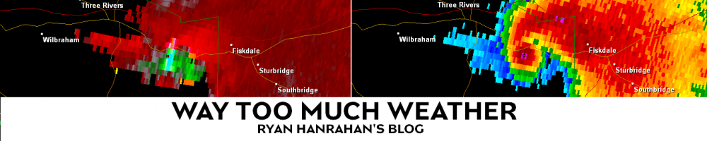
Just from the video I’ve seen and what I’ve seen personally as best I can determine the tornado touched down in Westfield and moved through West Springfield, and Springfield and then may have lifted in Wilbraham for a period of time. The damage up to this point was consistent with EF-2 damage though it’s possible there was a pocket of EF-3 damage in there but the National Weather Service will have a more definitive answer this afternoon.
The tornado touched down again somewhere near the Monson/Wilbraham line and continued east into Brimfield and then Sturbridge and Southbridge. There appear to be pockets of EF-3 damage in Monson and Brimfield (possibly Southbridge too?) and it’s conceivable that some EF-4 damage occurred. The construction of the buildings needs to be taken into account so it’s impossible for me to judge even having seen the damage up close. The Weather Channel’s Eric Fischer reported last night that one of the questions in the damage survey was how well constructed old wood frame houses are compared to modern construction. Again these are just my impressions based on the damage I saw in person and on video the NWS will release the final information.
I’ll try and post a more detailed meteorological review of the tornado this weekend. It appears that this tornado was another classic example of tornadogenesis occurring in a north/south oriented river valley in New York or New England. I’ll also try to post more on the damage and rating of this tornado once the National Weather Service releases their findings.
