I have egg on my face. No doubt about it. My forecast from Friday was a bust for parts of Connecticut. Here’s a look at what was predicted followed by what actually fell.

11 p.m. Friday Forecast

Actual snowfall on Saturday
Yikes. Busts happen. It’s the line of work we’re in. While most of Connecticut saw little accumulation (as expected) towns west of Route 8 and north of Torrington got pummeled by an isolated, but powerful, complex of snow.
Forecasting something like this isn’t easy. It’s akin to forecasting the developing and path of a summertime thunderstorm. In the summer, storms can drop 1″ or 2″ of rain on one side of a town and nearly nothing on the other side of a town. That’s the nature of the beast in the summer. In the winter our storms are generally much larger in area and affect a wide swath. Saturday’s storm was different.
There were signs of trouble, and an overperformer, yesterday. Here’s what I wrote on Twitter.

Twitter posts from 5:27 p.m. (bottom) and 10:43 p.m. (top)
As it turns out the interesting factor was high and by highly uncertain I meant really really really uncertain! So what was it about the storm that made it interesting and uncertain?
The setup for this storm featured a long inverted trough extending northwest from an area of low pressure well offshore. Low level convergence was occurring along this trough with northwesterly winds behind to the south and easterly and northeasterly winds to the north.

Meanwhile, modest quasi-geostrophic lift was occurring over southern New England with weak warm advection from the boundary layer to 850mb decreasing with height above that plus strong differential cyclonic vorticity advection ahead of a strong shortwave embedded in the long wave trough.

While the synoptics are fairly straightforward it was the mesoscale aspects of this storm that produced wild snowfall gradients from 0″ to 10″ in a relatively short distance. One of the signals on the computer models that this storm could be a challenge was an impressive amount of instability over the state. Instability can form convection (or thunderstorms) and that’s indeed what happened. In fact, upright convection formed over New Jersey and New York City with thundersnow, thunder graupel, and even actual hail near the Jersey Shore.
The 00z NAM computer model developed 100-200 j/kg of CAPE across Connecticut for this afternoon. That was a tip off something a little funky was going on. Additionally, models showed a spike of Total Totals (an instability index that is useful this time of year) into the mid 50s.

The morning weather balloon launch from Brookhaven, NY showed a conditionally unstable layer and I think the smoking gun here is the 3-hour forecast sounding for Canaan, CT off the 12z NAM.

3-Hour NAM BUFKIT Sounding for Canaan, CT Valid at 15z Saturday
Lapse rates are exceptionally steep from 800mb to 600mb – nearly 8C/km! In addition the sounding is saturated at this layer and the layer intersects with the snow growth zone of -12c to -18c. Upright convection like you’d see in the summer was favored in Connecticut.
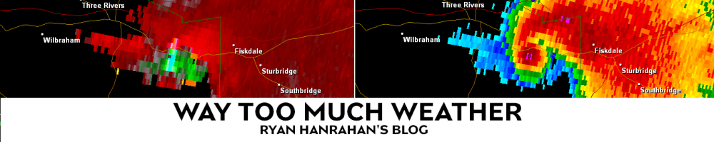
Indeed, upright convection is what happened. The convection was able to develop a mesolow (notice the spin below on radar) which is pretty unusual but not unheard of. Enhanced forcing to the north and west of the mesolow (frontogenesis) likely produced the pocket of 6″-10″ of snow on Route 44 near the Massachusetts border within the larger swath of 3″-6″. While elevation played some role I don’t think it was the biggest culprit here – mesoscale banding was by far more critical in determining which areas got the most snow.

Radar loop (click to animate)
At the end of the day this storm acted like a summertime thunderstorm (the process that produces summertime storms – convection – is exactly the same as what we had today). We don’t even attempt to pin down the exact location, track, and intensity of a specific thunderstorm 12 hours out in the summer – it’s something that no one has the skill today. We can mention the threat for a thunderstorm but they are, by nature, relatively hit or miss. In the winter, the impact can be large with a swath of heavy snow while in the summer a band of 1″-2″ of rain from a cluster of thunderstorms like this would have relatively little impact.

Courtesy: Karen Wilson / Norfolk
Regadless, this storm is in the books. As always the weather never ceases to amaze and there’s always something new to learn. Forecast busts happen and when they do it’s best to acknowledge the error and move on – there’s always another bust lurking around the corner 🙂
